Remote Sensing using Satellites and Drones
Imagery captured by satellites has been vital for the science of Earth Observation and remote sensing since the launch of the first artificial satellite in 1957. Currently, there are more than 150 satellites performing Earth Observation tasks in the Earth’s orbit. Passive sensors mounted on satellites capture the electromagnetic radiation emitted by the Earth to produce multispectral imagery, which can be utilized for the optical monitoring of the Earth’s surface. With their ability to autonomously monitor large stretches of land, satellites provide a time and cost effective tool for land surveying. Additionally, modern satellite missions such as ESA’s Sentinel-2 can provide new imagery as frequently as every three days allowing for monitoring of changes over short periods of time.
To make monitoring at such a level possible, satellites operate at very high altitudes. As a result, satellites alone are sometimes not enough to capture imagery at the level of detail needed for modern land surveying. An alternative that has gained popularity within the past years is the use of Unmanned Aerial Vehicles, commonly called drones, for data capture. While satellites can provide a “macro-look” over large swaths of area, drones are able to record information at a much finer detail. Commercial drones can provide imagery at resolutions as low as 10 centimeters per pixel and improvements in remote control of modern drones allows for quick deployment and easy maneuvering. As drones need to be operated manually, however, the cost and time needed for the acquisition of drone imagery is a lot higher than the price of traditional satellite imagery.
Since satellites as well as drones possess their unique advantages and disadvantages for remote sensing combining the two is necessary to create interesting synergies and dissolve the disadvantages of both solutions. By bringing together high resolution optical satellite and drone imagery, the AI-based analysis created at Spacept allows for the utilization of the full potential of both of the tools for high precision geospatial analysis for a range of applications such as vegetation monitoring.
Climate Resilient Vegetation Monitoring at Spacept
Regular monitoring of vegetation around infrastructure such as powerlines is crucial for the prevention of damages caused by the encroachment of trees and shrubs. As shown by an analysis performed at Spacept in September 2021, encroachment of trees into power lines could have contributed to a number of wildfires in California during the Summer of 2021. Traditionally monitoring of vegetation is performed through in-field surveys or manual interpretation of satellite or aerial imagery. With power lines spanning hundreds of kilometers, these manual inspection techniques are both time and cost consuming. Leveraging the specific advantages of both satellite imagery and drone data when performing land surveying helps save time, cost and emissions. A recent case study performed jointly by Spacept and a drone services provider shows an overall cost reduction of around 80% during infrastructure inspection when using Spacept’s monitoring tools.
The use of satellite data together with Spacept’s AI-powered analysis provides a cost-effective alternative to traditional in-field measurements. As a first step, a macro analysis is performed along the powerline to identify possible areas of encroachment using high resolution imagery in combination with Spacept’s machine learning algorithms. Once they have been identified, drones are deployed to investigate these high-risk areas and determine next steps of action. As such, a broad analysis over the entire power line can be performed within minutes, while still retaining a high level of detail through the use of the drones where necessary. As a supplementary tool, the monitoring of tree encroachment using satellites can be performed between the less frequent in-detail inspection already performed by many infrastructure companies to provide companies with ongoing information on risk levels.
Apart from vegetation monitoring, Spacept offers a variety of analysis ranging from infrastructure maintenance and street light monitoring to oil spill detection and the delineation of building footprints.
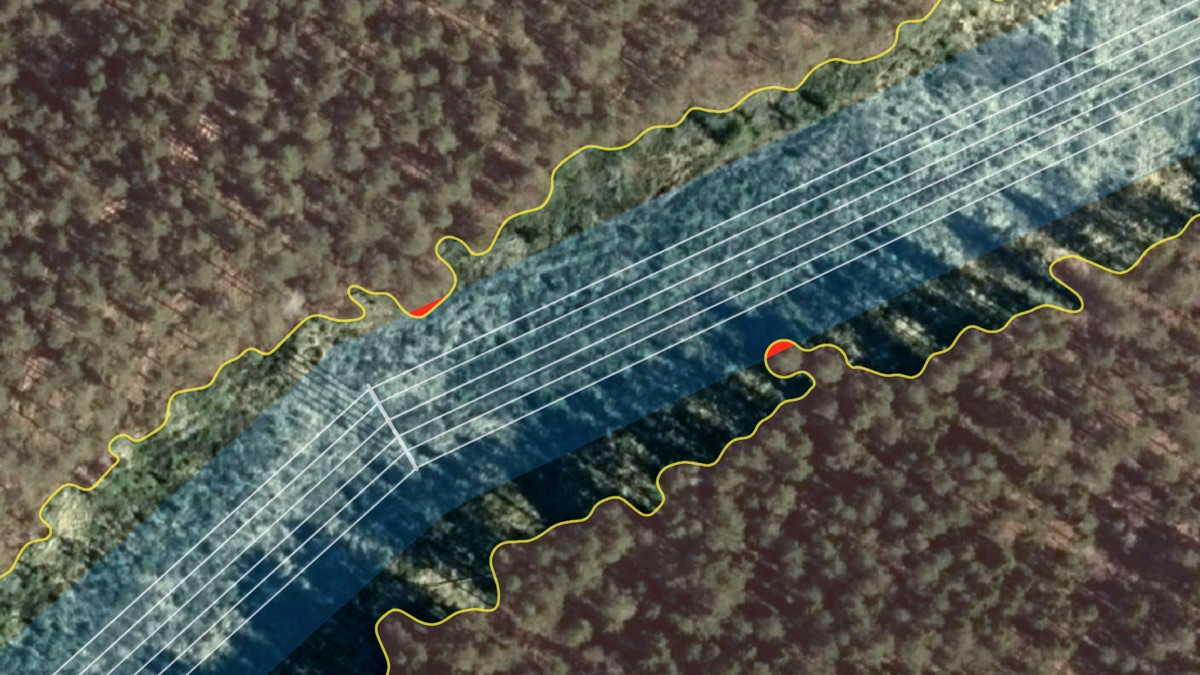
Areas of encroachment risk identified by the Spacept Tree Detection Model.
Conclusion
The solutions presented by Spacept empower companies to identify potential risks and mitigate hazards before they arise. As extreme weather events such as very dry and hot summers are expected to increase as a result of climate change a proactive approach to vegetation management will be needed to ensure the protection of local ecosystems and infrastructure. Spacept can help infrastructure companies in integrating a climate resilient monitoring system and meet the increasing demands for more frequent and in-detail vegetation monitoring. With satellite imagery continuously improving in both quality and resolution, adopting Earth Observation data as part of infrastructure monitoring work streams will be an essential step towards preparing utility companies for a changing climate.
Learn more about Spacept
Spacept is a Swedish startup with solutions that lie at the intersection of infrastructure inspection and climate change management. The solution aims to modernize infrastructure inspection by fusing machine learning techniques and satellite imagery together, providing key insights to infrastructure operators.
Our main product is an inspection solution for above-ground transmission and distribution lines. In addition, we also have other products for oil and gas pipelines, street lights, railways, buildings, and roads.
Our trailblazing work in Geographic Information Systems (GIS) has been recognized by Copernicus, the European Space Agency (ESA), Digital Tech 50 (DT50), the Swedish government, Google’s SDGs Startup Accelerator, and Oslo’s Innovation Week.
Our technological expertise has led us to become one of the most innovative Swedish based AI companies at Futurology. Furthermore, we are one of the most promising companies impacting the ASEAN energy ecosystem in Initiate’s Future of Energy Start-up Challenge in Asia.